"Density Form and Transportation"
“Density Form and Transportation.”
This essay will explain how the city forms and how the constraint such as transportation development configured the city form. City is an arrangement of various forms and functions of buildings.
‘A city is a relatively large and permanent settlement’.
Referring to the explanation above, there are several elements that make up a city. The city's development started from the hierarchy of logical rehabilitation stages. Human has natural behaviour. Natural behaviour creates social life. Social life creates activity. Activity creates function system. Function system creates buildings and roads, and finally buildings, and roads build a city. This theory called the functional city’.
In an effort towards functional city, another problem has arisen, creation of lost space’. According to Roger Trancik in his book, finding lost space: theories of urban design; lost space is an unshaped anti space that existed at the leftover unstructured landscape, unused sunken plaza, parking lots, and abandoned waterfronts, train yards, vacated military site and industrial complexes.
The characters of lost space are ill defined, without measurable boundaries and fail to connect elements in a coherent way.
This problem has become more complex and lead to a loss of identity of city’s density. Among the causes been listed by Trancik, dependence on the automobile is the most difficult to deal.
This essay will explain the transition process by studying the history of urban development. It will also questioning how the emergence of the modernisation of transportation technology has an enormous impact to forming urban density form.
The Problem

Figure 1:
Ancient City Concept
Diagram above describes the layers forming an ancient
city. The concept denies the existence of lost space. Normally, walking or
cycling is the suitable methods of communication for this kind of city.

‘From the 1950s, the growth of
suburbs was mainly taking place adjacent to major road corridors, leaving a lot of vacant/farm land in
between. Later, intermediate spaces were gradually filled up, more or less
coherently. Highways and ring roads, which circled and radiated from cities,
have favored the development of suburbs and the emergence of important
sub-centers that compete with the central business district for the attraction
of economic activities.’ 5
Based on the
above statement, the construction of road corridors have developed empty space
in between, which also called ‘lost
space’.
The Evolution
The Ancient Cities
The ancient cities generally were formed by the
function of the city itself. The formation of the cities usually consisting of
a center building (palace or administrative or religious building) while
streets and other buildings surrounded it. The examples are Timgad (Romans) and
Beijing (China).
‘The Romans modified the Greek order of town
planning to suite their own order, with its intense centralization of the power
structure, by introducing the axis and creating major linear focus in the grid
organization.’ 6

Figure 3: Old Timgad Layout 7 & Diagram
of Timgad (Roman)
While in
Beijing China, the form and grid had related to the political sense. Where the
palace is situated at the center of the city and the rest were developed around
it. 8

Figure 4: Satellite
Photo of Beijing 10 & Diagram of Old Beijing (China)
Most cities in the 20th century are not
using the traditional grid concept. The modern building typologies had replaced
it. The enclosed blocks with large open courtyards is the main character of
this concept. It was used in Berlin in 1890s. 11

Figure 5:
Berlin, Germany (1890s) 12 & Diagram of Berlin
The other example is Amsterdam; the city
traditional grid form was replaced by the modern building typology. The grid is
likely having long courtyard-framing housing blocks with similar uniformity of
facades. 13

Figure 6:
Amsterdam, Netherland (1915) 14 & Diagram of Amsterdam
‘Historically,
movements within cities tended to be restricted to walking, which made medium-
and long-distance urban linkages rather inefficient and time consuming. Thus,
activity nodes tended to be agglomerated and urban forms compact.’ 15
Comparing
the grid pattern of ancient cities with the 20th century cities, we
can see the urban sprawl has changed dramatically from a dense populated to a
courtyard-framing area.
‘However, the increasing growth of traffic couldn’t make do
without the grid. The boundaries of cities increased due to automobiles,
leading to growth in traffic, making streets extremely dangerous.’ 16
There are three major factors
why the urban form changes. First, the urban
population growth (doubled since 1950), 17 invention of modern highways in 18th century and the creation of modern gasoline or petrol cars
in 1885. 18
‘The evolution of transportation
has generally led to changes in urban form. The more radical the changes, the
more the urban form have been altered.’ 19
From the diagram below, there
is no significance change from 100 AD to 1406 cities, but the gaps between
buildings emerged started from 1890 city and continue wider in 1915 city
diagram.

Figure 7: The
Evolution of City Pattern
Case Study: Kuala Lumpur, Malaysia (1857)
Kuala
Lumpur is the capital city of Malaysia. The city has begun in 1857 at the
confluence of the Gombak and Klang rivers. Founded by Raja Abdullah, a member
of the Selangor royal family, he opened up the Klang Valley for tin
prospectors. 20

‘At the other end of the spectrum,
the dispersed urban forms of most Australian, Canadian and American cities
which were built recently, encourage automobile dependency.’ 22
As
the technology grows Kuala Lumpur is relying so much on roads and railway
tracks. Since then, it has continuously influencing the city form making Kuala
Lumpur an automobile dependency city.

Figure 9:
Kuala Lumpur Map (1889) 23 & Diagram of KL 1889
The maps and
diagrams show the urban sprawl in Kuala Lumpur. It was concentrated along the
rivers and railway track, as they were the main transportations modes.

Figure 10:
Kuala Lumpur Map (1895) 25 & Diagram of KL 1895
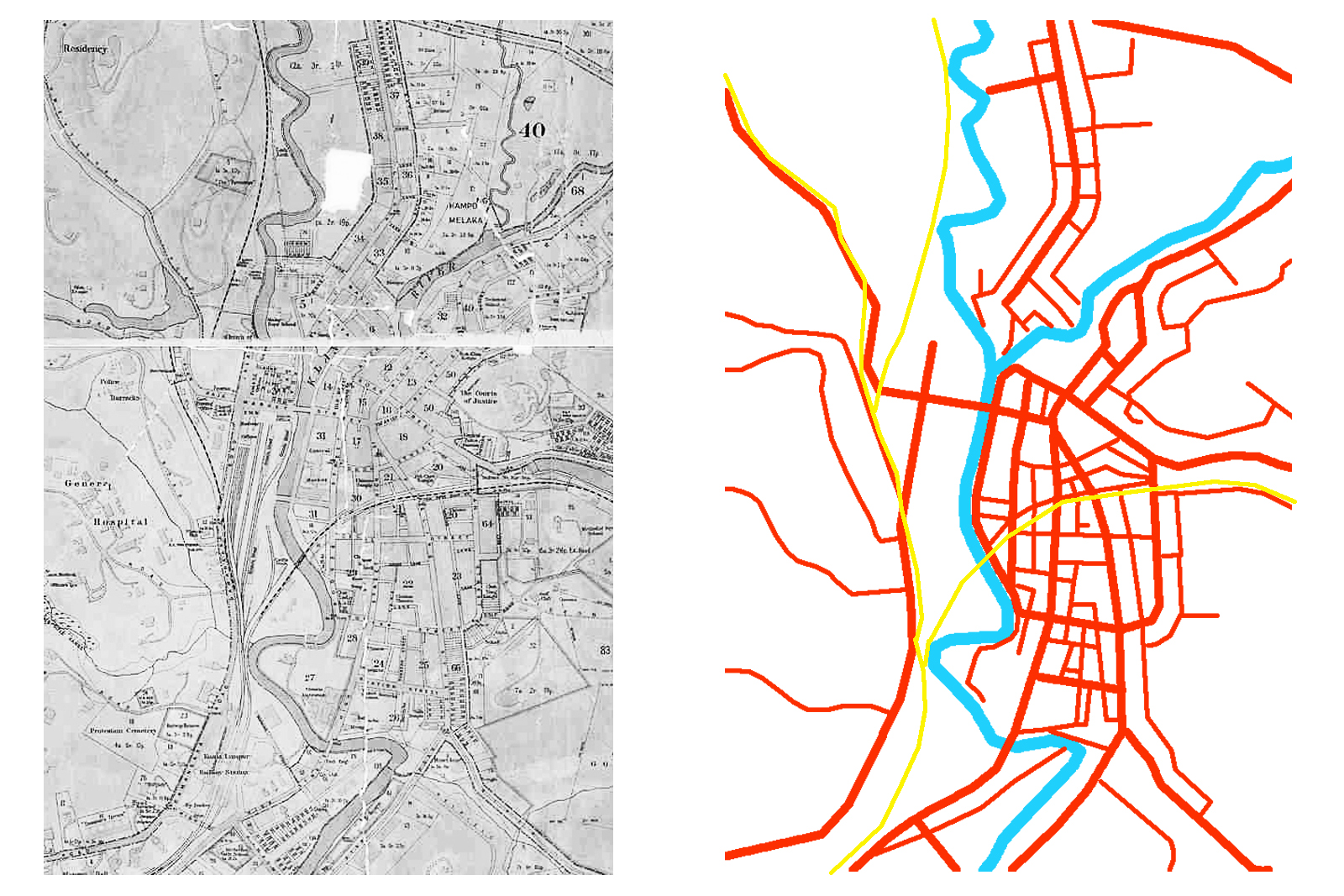
Figure 11:
Kuala Lumpur Map (1908) 26 & Diagram of KL 1908

Figure 12: Kuala Lumpur Map (1922) 27 & Diagram of KL
1922
The
dispersion or urban sprawl in Kuala Lumpur and the other 20th
century cities were fast and uncontrolled. Therefore, lost spaces formed indirectly between urban core and suburban
areas.
In sustainable urban design strategies, these
lost spaces should be integrated in the design and transformed into functional
sustainable spaces.
Functional Sustainable Spaces
To create
functional sustainable spaces in urban, designers should view the city as a
whole. The urban elements such as buildings, roads, parking spaces, and etc. should
be designed within the demands of the users. The following are some strategies
to create functional sustainable spaces.
Compactness - ‘Compactness of urban space can minimize transport of energy, water,
materials, products and people.’ (Elkin, McLaren, and Hillman 1991) 28.
Compact city design can create better sustainability and resilience of energy
and resources. Through the compactness as well, empty space can be reduced, for
example building a multilevel car park can reduce a large parking area.
Sustainable Transport - ‘Sustainability is defined as diminishing
both mobility and the negative of traffic.’ (Elkin, McLaren, and Hillman 1991) 29 Transportation is
the biggest issue in urban area, providing a sustainable transport system can improve
urban quality even more economical.
Density - ‘Increasing the urban density; strengthening
the city center; extending the proportion of a city that has inner-area land
use; providing a good transit option; and restraining the pro-vision of
automobile infrastructure.’ (Newman and Kenworthy 1989) 30.
High density in a city will encourage the usage of
public transport while low density will promote the use of private vehicles.
Mixed Land Uses - ‘Mixed land use
reduces the probability of using a car for commuting, shopping, and leisure
trips, since jobs, shops, and leisure facilities are located nearby.’ (Alberti
2000; Van and Senior 2000) 31. This
concept is similar to the ‘new urbanism’ concept that supports utopian goals.
If all the daily needs are accessible by walking, there will be less use of
private vehicles.
Diversity - ‘Diversity is vital; without it, the urban
system declines as a living place and a place to live.’ (Jane Jacobs 1961) 32 Makes the place lively and attract
people to be apart of the community, which at the same time encouraging walking
to experience the desirable place.
Greening - Greening of the city makes urban and suburban
places appealing and pleasant.’ (Van der Ryn and Cowan 1995; Nassauer 1997) 33
Greening the city can contributes positive impact to surrounding which offers
fresh air and look.
Conclusion
The modernization of transportation
technology has given a big impact to urban density form. In connection with
that, sub-core areas have been emerging and indirectly create lost spaces in
between. However, these lost spaces could be a new element that provides a
positive impact to urban form.
References
1.
Jean-Paul,
R., 2006. Chapter 7: Urban transportation. In The geography of transport
systems. New York: Taylor & Francis.
2.
Trancik, R., 1986. Finding lost space:
theories of urban design, New York: John Wiley & Sons, Inc.
3. Kostos, S.,
1991. The city shaped: urban patterns and meanings through history,
Boston: Bulfinch Press.
4. Jabareen,
Y.R., 2006. Sustainable urban forms: Their typologies, models and concepts. Association
of Colegiate Schools of Planning, pp.39-48.
5. Falconer, J 1987, A vision of the past: a history of early
photography in Singapore and malaya, Times, Singapore.
6. Anon, 2009.
History of railways around kuala lumpur. Asian Railways. Available at:
http://searail.mymalaya.com/ [Accessed November 9, 2011].
7. Wikipedia. Available at:
http://en.wikipedia.org/wiki/ [Accessed November 16, 2011].
Prepared by:
Mohd Firrdhaus Mohd Sahabuddin
The University of Edinburgh
Edinburgh School of Architecture and Landscape Architecture (ESALA)
2011


salam firdhaus,
ReplyDeleteinteresting writing on development of urban sprawl. saya sedang buat study about KL mapping, boleh saya tahu kat mana dapat main source of map Kuala Lumpur sebelum 1900's?
Terima Kasih
Arkib Negara maybe ada tuan...
ReplyDelete